
Aquatica San Diego blends up-close animal experiences, waters from serene to extreme, high-speed thrills and a sandy beach into a one of a kind water park.
State: California
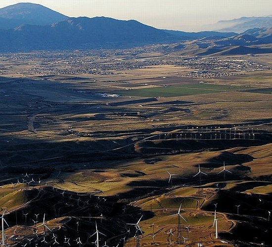
Wind farms with Tehachapi in the distance.
—
Features
The Tehachapi area is known for the nearby Tehachapi Loop (a popular railfan site), Tehachapi Pass Wind Farm, The Indian Point Ostrich Ranch, the Tomo-Kahni State Historic Park and Tomi-Kahni Resource Center (Native American),[10] and excellent air conditions for gliding. Ten miles to the west at Keene, is the National Chavez Center,[11] established to share the legacy of Cesar Chavez.
The California Correctional Institution maximum security prison, also known as Tehachapi State Prison, is in the area; as is proximity to Edwards Air Force Base (40 miles to the east).
History
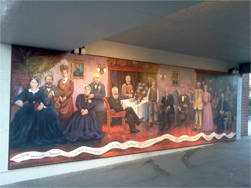
The Errea House, originally built in the early 1870s in Tehichipa, was moved to Techachapi in 1900 and is now a museum; it is also listed on the NRHP.
The Kawaiisu people (also Nuwu (“people” in Kawaiisu), or Nuooah) are the Native American tribe whose homeland was the Tehachapi Valley, and seasonally the southern Sierra Nevada and Mojave Desert, for thousands of years.
One possibility for the origin of the name Tehachapi comes from the Kawaiisu language. It may be derived from the word for “hard climb” or tihachipia, according to the Tomi-Kahni Resource Center.[12] The settlement has been formerly known and spelled as: Tehachapai;[6] Tehachapa;[6] Tehachepi;[6] Tehachipi;[6] and Summit Station.[9]
Previously known as ‘Old Town’, Tehachapi was established in the 1860s. It is now registered as California Historical Landmark #643 for being the oldest settlement in the Tehachapi Valley.[13]
Construction of the original Southern Pacific-SP railroad depot was the beginning of the downtown core. It is now on the National Register of Historic Places (NRHP)—and was the oldest building in downtown Tehachapi until it burned in June 2008. The building had been in the final stages of becoming a museum.[14] It has since been rebuilt using the original plans with only minor modifications to meet modern building codes. The new depot was dedicated on June 5, 2010.[15]
On July 21, 1952 Tehachapi was devastated by a magnitude 7.5 earthquake on the little-known White Wolf Fault.
Demographics
The population was 14,414 at the 2010 census, up from 10,957 at the 2000 census.
Historical population
Census Pop. %±
1890 255 —
1910 385 —
1920 458 19.0%
1930 736 60.7%
1940 1,264 71.7%
1950 1,685 33.3%
1960 3,161 87.6%
1970 4,211 33.2%
1980 4,126 −2.0%
1990 5,791 40.4%
2000 10,957 89.2%
2010 14,414 31.6%
Est. 2016 12,495 [8] −13.3%
U.S. Decennial Census[16]
2010 details
The 2010 United States Census[17] reported that Tehachapi had a population of 14,414. The population density was 1,445.7 people per square mile (558.2/km²).
Diversity
The racial makeup of Tehachapi was 9,426 (65.4%) White, 1,297 (9.0%) African American, 206 (1.4%) Native American, 238 (1.7%) Asian, 21 (0.1%) Pacific Islander, 2,725 (18.9%) from other races, and 501 (3.5%) from two or more races. Hispanic or Latino of any race were 5,466 persons (37.9%).
The Census reported that 8,487 people (58.9% of the population) lived in households, 6 (0%) lived in non-institutionalized group quarters, and 5,921 (41.1%) were institutionalized.
There were 3,121 households, out of which 1,199 (38.4%) had children under the age of 18 living in them, 1,504 (48.2%) were opposite-sex married couples living together, 418 (13.4%) had a female householder with no husband present, 181 (5.8%) had a male householder with no wife present. There were 194 (6.2%) unmarried opposite-sex partnerships, and 18 (0.6%) same-sex married couples or partnerships. 879 households (28.2%) were made up of individuals and 428 (13.7%) had someone living alone who was 65 years of age or older. The average household size was 2.72. There were 2,103 families (67.4% of all households); the average family size was 3.34.
The population was spread out with 2,599 people (18.0%) under the age of 18, 1,542 people (10.7%) aged 18 to 24, 5,891 people (40.9%) aged 25 to 44, 3,115 people (21.6%) aged 45 to 64, and 1,267 people (8.8%) who were 65 years of age or older. The median age was 34.4 years. For every 100 females there were 234.8 males. For every 100 females age 18 and over, there were 283.0 males.
There were 3,539 housing units at an average density of 354.9 per square mile (137.0/km²), of which 1,841 (59.0%) were owner-occupied, and 1,280 (41.0%) were occupied by renters. The homeowner vacancy rate was 3.2%; the rental vacancy rate was 12.2%. 4,913 people (34.1% of the population) lived in owner-occupied housing units and 3,574 people (24.8%) lived in rental housing units.
2000 details
As of the census[18] of 2000, there are 10,957 people, 2,533 households, and 1,709 families residing in the city. The population density is 1,144.0 people per square mile (441.6/km²). There are 2,914 housing units at an average density of 304.2 per square mile (117.4/km²).
Diversity
The racial makeup of the city is 57.17% White, 13.80% Black or African American, 1.35% Native American, 0.74% Asian, 0.16% Pacific Islander, 23.82% from other races, and 2.97% from two or more races. 32.70% of the population are Hispanic or Latino of any race.
There are 2,533 households out of which 35.6% have children under the age of 18 living with them, 47.5% are married couples living together, 14.3% have a female householder with no husband present, and 32.5% are non-families. 28.8% of all households are made up of individuals and 13.5% have someone living alone who is 65 years of age or older. The average household size is 2.59 and the average family size is 3.19.[citation needed]
In the city, the population is spread out with 18.5% under the age of 18, 12.9% from 18 to 24, 42.7% from 25 to 44, 16.5% from 45 to 64, and 9.4% who are 65 years of age or older. The median age is 33 years. For every 100 females there are 224.8 males. For every 100 females age 18 and over, there are 270.0 males.[citation needed]
The median income for a household in the city is $29,208, and the median income for a family is $40,030. Males have a median income of $50,446 versus $26,023 for females. The per capita income for the city is $18,220. 20.4% of the population and 17.4% of families are below the poverty line. Out of the total population, 24.5% of those under the age of 18 and 15.5% of those 65 and older are living below the poverty line.
================================================
Statistic how many times this Ad$mart was shared.
==========================
=========================

Tehachapi, California
Tehachapi is a city in Kern County, California, in the Tehachapi Mountains, at an elevation of 3,970 feet (1,210 m) between the San Joaquin Valley and the Mojave Desert.
A rare megamouth shark washed ashore dead in the Philippines this week (January 30, 2015). The 15-foot shark, a Megachasma pelagios (or “giant mouth of the deep”), was discovered on the beach in Marigondon, Pio Duran, in Albay province. 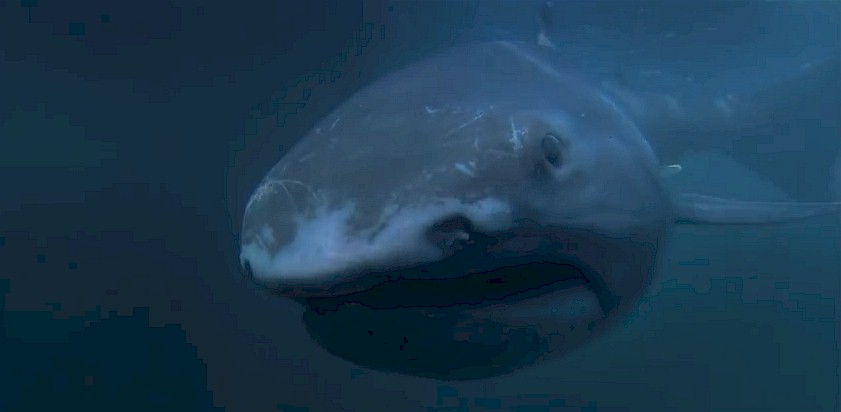
The totally terrifying-looking specimen is one of less than 70 ever seen in the world, according to Marine Wildlife Watch of the Philippines. The shark, nicknamed “Toothless,” was preserved in ice by local villagers.
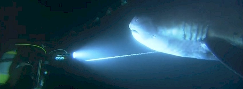
| It’s the first megamouth shark to be documented since July, when an 18-foot Megachasma pelagios was caught by Filipino fishermen. The first confirmed megamouth shark sighting was in 1976, when a deep-sea anchor accidentally caught one near Hawaii. Most have been found in Japan, the Philippines and Taiwan. Despite the recent sightings, the megamouth shark remains “one of the most rarely seen species of sharks,” David Shiffman, a marine biologist, told Business Insider. | Little is known about the species. According to the Shark Devocean blog, the deepwater shark is just one of three species (along with whale and basking sharks) that feed on plankton. The slow-moving giant bottom-feeder swims with its big mouth wide open, filtering water for plankton and jellyfish. The largest, discovered in waters off Taiwan, measured 19 feet. The sharks can live to about 100, according to Reuters. |
—————————————————————————
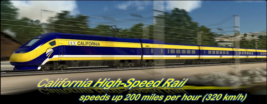
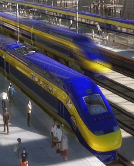
The planned line would connect Los Angeles with San Francisco by 2029 with speeds up 200 miles per hour (320 km/h) and allow for future extensions to San Diego and Sacramento. Initial funding for the project was approved by California voters on November 4, 2008, and authorized the issuance of US$9.95 billion in bonds for the project.
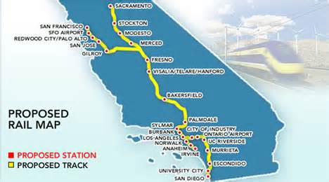
The first phase of the line will be constructed in three interconnected segments: one in the Central Valley, one linking the Central Valley to the Los Angeles Basin, and another linking the Central Valley to the San Francisco Bay Area. Future segments include routes to Sacramento and San Diego. |
 |
 |
The project’s cost and scope have long been a source of controversy. The California High-Speed Rail Authority has estimated the project’s year-of-expenditure cost at $68.4 billion (2011 estimate). In July 2014 The World Bank reported that the per kilometer cost of California’s high-speed rail system was $56 million, less than Phase 1 of High Speed 2 in the United Kingdom ($173 million per km), but more than the average cost of $17–21 million per km of high speed rail in China and $25–39 million per km for similar projects in Europe.The system will extend from San Francisco and Sacramento, via the Central Valley, to Los Angeles and San Diego via the Inland Empire. As planned, the track from San Francisco to Los Angeles would be 520 miles (840 km). Possible stations are shown on the statewide rail modernization map at right. In January 2012, the Authority released a study, started in May 2011, that favors a route through Antelope Valley over one that parallels Interstate 5 |
Sustained construction began on January 6, 2015 with the first major segment starting this spring.
—–$$$———————————————————————————————————–
To help generating income for this project click here.
——————————————————————————————–$$$——————–

Sequoia National Park is a national park in the southern Sierra Nevada east of Visalia, California, in the United States. It was established on September 25, 1890. The park spans 404,063 acres (631.35 sq mi; 1,635.18 km2). Encompassing a vertical relief of nearly 13,000 feet (4,000 m), the park contains among its natural resources the highest point in the contiguous 48 United States, Mount Whitney, at 14,505 feet (4,421 m) above sea level. The park is south of and contiguous with Kings Canyon National Park; the two are administered by the National Park Service together as the Sequoia and Kings Canyon National Parks.
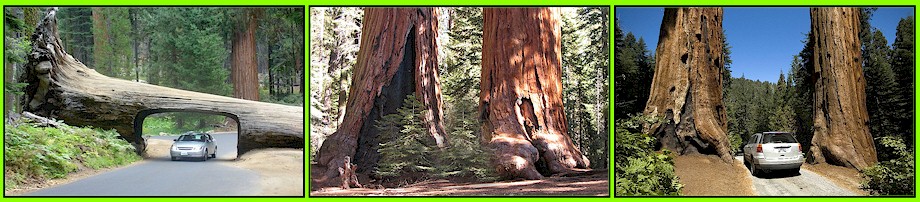
The park is famous for its giant sequoia trees, including the General Sherman tree, one of the largest trees on Earth. The General Sherman tree grows in the Giant Forest, which contains five out of the ten largest trees in the world. The Giant Forest is connected by the Generals Highway to Kings Canyon National Park’s General Grant Grove, home to the General Grant tree among other giant sequoias. The park’s giant sequoia forests are part of 202,430 acres (81,921 ha) of old-growth forests shared by Sequoia and Kings Canyon National Parks. Indeed, the parks preserve a landscape that still resembles the southern Sierra Nevada before Euro-American settlement.
Park attractions
In addition to hiking, camping, fishing, and backpacking, the following attractions are highlights with many park visitors:
- Sherman Tree Trail An 0.8-mile roundtrip paved trail that descends from the parking lot to the base of the General Sherman tree and meanders through a grove of giant sequoia trees.
- Tunnel Log is a tunnel cut through a fallen giant sequoia tree in Sequoia National Park. The tree, which measured 275 feet (84 m) tall and 21 feet (6.4 m) in diameter, fell across a park road in 1937 due to natural causes. The following year, a crew cut an 8-foot (2.4 m) tall, 17-foot (5.2 m) wide tunnel through the trunk, making the road passable again.
- Tokopah Falls The trail to Tokopah Falls starts just beyond the Marble Fork Bridge in Lodgepole Campground. It is an easy 1.7 mile (one way) walk along the Marble Fork of the Kaweah River to the impressive granite cliffs and waterfall of Tokopah Canyon. Tokopah Falls is 1,200 feet (365.8 meters) high, and is most impressive in early summer.
- Crescent Meadow is a small, sequoia-rimmed meadow in the Giant Forest region of Sequoia National Park. This sierran montane meadow marks the western terminus of the High Sierra Trail, which stretches from the meadow across the Great Western Divide to Mount Whitney. Pioneer Hale Tharp homesteaded in this and nearby Log Meadow. Conservationist John Muir visited this meadow many times and praised it highly calling it the “Gem of the Sierras”. The meadow lies at the end of a three-mile paved road which leaves the Generals Highway near the Giant Forest Museum.
- Moro Rock is a granite dome located in the center of the park, at the head of Moro Creek, between Giant Forest and Crescent Meadow. A 400-step stairway, built in the 1930s by the Civilian Conservation Corps, is cut into and poured onto the rock, so that visitors can hike to the top. The stairway is listed on the National Register of Historic Places. The view from the rock encompasses much of the Park, including the Great Western Divide. It has an elevation of 6,725 feet (2,050 m).
- Campgrounds in the park include three in the foothills area: Potwisha (42 sites), Buckeye Flat (28 sites), and South Fork (10 sites). Four campgrounds are at higher, conifer-dominated elevations, ranging from 6,650 to 7,500 feet (2,000 to 2,300 m): Atwell Mill (21 sites), Cold Springs (40 sites), Lodgepole (214 sites), and Dorst Creek (204 sites).
- Giant Forest Museum offers information about giant sequoias and human history in the forest. The historic museum was built in 1928 by architect Gilbert Stanley Underwood.
Earn 25% Rebate from your travel expenses.

Vacations are your best chance in the year to get in some real living, to get out of the job-as-life box, off automatic pilot, and rediscover your passions, enthusiasms, friends, family, and the vitality of partaking in the world outside career brainlock.

Social scientists have found that leisure experiences increase positive mood, act as a buffer against life’s setbacks, and open the door to the best times of our lives.
Do You EVE? Difference – A way of life and tools and guidance you need to succeed.
|
|
1. Professional Coaching Certification & Dynamic Coaching Community Certification and continuing education in professional coaching and business development. What can life coaching certification give you? If you want to get a job in training, coaching and leadership development or start your own coaching business, this is a place to jump start it. PROFESSIONAL COACHING CERTIFICATION, APPLICABLE TO ALL DISCIPLINES (Life, Career, Executive, Wellness, Weight Loss Coaching and more)
2. Coaching Services: Career, Business, Executive Leadership Coaching & Training For details, sample coaching plans, please visit our Web site. |

INDIVIDUALS-Get That Job Fast!
- Do any of the following apply to you?
- Do you need a new job or career?
- Do you want more interviews?
- Do you want recruiters to call you?
- Do you want to start a business?
If you have answered “yes” to any of the above questions or have a related question, we are ready to help you. Contact us now!
|
Mind First, since your mind is the dashboard, which controls everything else, you must prepare for change by getting your mind ready. Without a firm and conscious commitment, stemming from your mind, change cannot happen. |
|
|
Body
Next, in order to recover and be fully restored, you need to pay close attention to your physical state and needs and your overall sense of well-being. You will take the steps to improve how you take care of your body, be it relaxation, nutrition |
|
|
Soul
Last but not least, in order to to make your preparation to reinvent yourself, you must have your soul at peace. You need a spirit of hope, joy, and fulfillment to dominate your state of mind and your existence.
|
The Do You Eve? Reinvention Principals. After you have your mind, body, and soul in harmony, you’re ready to explore your reinvention.
Extensive Essential Services Portfolio
The best part about the this business model is its simplicity – and the potential! Independent Business Owners (IBOs) offer their customers services they are already using and spending money on anyway through their very own, personalized Direct Online Store, services such as phone service, wireless, gas and electricity, merchant services, high speed internet, home security and automation, television – and more. There is no change in buying habits and IBOs don’t have to convince customers to purchase services they don’t need or can’t afford.

Video Phone Primary Service Feature:
Unlimited local & long distance calling to US, Canada and Puerto Rico,
- 7″ touch screen,
- high definition audio,
- true to life video quality,
- Wi-Fi, build-in customizable apps… and more
